As the son of an oceanographer and map maker I have loved maps and GIS as long as I can remember. These projects show a variety of skills and software use including:
- ArcGIS
- QGIS
- Map Preservation and Digitization
- Non Traditional Uses of GIS
The links below will take you to an number of projects, including:
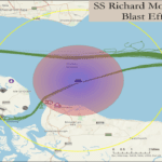
- Dangerous Waters – a research project looking at the impact of World War Two shipwrecks with custom maps using ArcGIS
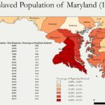
- Oceans of Kinfolk – Mapping project assisting a doctoral candidate looking at the forced movements of enslaved people in the pre Civil War period
- Grandfathers Maps – Preservation and digitalization of World War Two maps of France used by my Grandfather during his time as a US Cavalry officer in the European Theater of Operation in 1944-45.
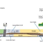
- Geographic Information and Hobbies – The use of GIS tools and information in public libraries to support hobbies like model railroading, bird watching and fishing.